


-
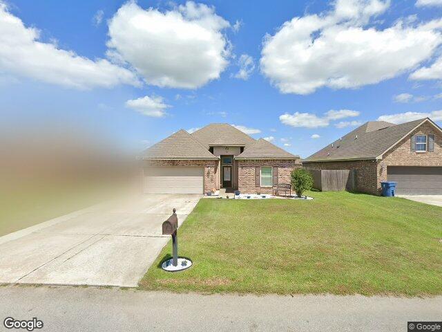
226 BROLAND DR DUSON, LA 70529
- Single Family Home / Resale (MLS)

Register to view full details of all properties including foreclosures, Hud Homes and more. View Homes
Property Details for 226 BROLAND DR, DUSON, LA 70529
Features
- Price/sqft: $134
- Lot Size: 10019 sq. ft.
Facts
- Year Built: 01/01/2014
- Property ID: 938900402
- Parcel Number: 6152809
- Property Type: Single Family Home
- County: LAFAYETTE
- Legal Description: LOT 64 ARROWWOOD SUBD PH 2 (60X167.25)
Contact Info for 226 BROLAND DR, DUSON, LA 70529
This is NOT a Foreclosure listing. It is a traditional Resale (MLS) listing. Negotiate your purchase with the sellers agent.
Agent(s)
David Wenger
EXP Realty LLC
EXP Realty LLC
Agent(s)
Exp Realty, Llc
Price Information
FirstAmerican Estimates
- Market Value : $223,079
- Low Value : $205,026
- High Value : $241,131
- Confidence Score : 94%
Local Info for 226 BROLAND DR, DUSON, LA 70529
Education 70529
- Not High School Graduates 33.55%
- Some College 20.50%
- Bachelor’s Degree 13.12%
- Graduate Degree 7.93%
- Closest Two-year Public College
SOUTH LOUISIANA COMMUNITY COLLEGE (6 miles) - Closest Four-year Public College
UNIVERSITY OF LOUISIANA-LAFAYETTE (8 miles)
Age 70529
- Infants and Children: 2,428
- Teens: 484
- 20 - 39 yrs old: 2,873
- 40 - 59 yrs old: 2,933
- 60 + yrs old: 2,429
Income 70529
70529 - DUSON, Louisiana
- Median Per Capita Income: $49,841
- Median Household Income: $54,350
- Average Household Income: $71,878
- Average Individual Income: $26,036
- Income Change Since 2010: $11.21
Louisiana
- Median Per Capita Income: n/a
- Median Household Income: $52,478
- Average Household Income: $74,220
- Average Individual Income: $28,718
- Income Change Since 2010: $13.73
Crime 70529
70529 - DUSON, Louisiana
- Total Crime Risk : 15
- Personal Crime Risk : 124
- Murder Risk : 137
- Rape Risk : 177
- Robbery Risk : 78
- Assault Risk : 143
- Property Crime Risk : 123
- Burglary Risk : 159
- Larceny Risk : 138
- Motor Vehicle Theft Risk : 70
Louisiana
- Total Crime Risk : 205
- Personal Crime Risk : n/a
- Murder Risk : n/a
- Rape Risk : n/a
- Robbery Risk : n/a
- Assault Risk : n/a
- Property Crime Risk : n/a
- Burglary Risk : n/a
- Larceny Risk : n/a
- Motor Vehicle Theft Risk : n/a
Environment 70529
70529 - DUSON, Louisiana
- Average Annual Rainfall : 60.29
- Air Pollution Index : 75.00
- Average July Temperature: (°F) 82.20
- Average July High Temperature: (°F) 91.40
- Average January Temperature: (°F) 50.51
- Average January Low Temperature: (°F) 40.74
Louisiana
- Average Annual Rainfall : 60.24
- Air Pollution Index : 73.00
- Average July Temperature: (°F) 82.10
- Average July High Temperature: n/a
- Average January Temperature: (°F) 48.76
- Average January Low Temperature: (°F) 38.66
Demographic 70529
Ethnicity
- White: 9,325
- Black: 1,619
- Indian: 21
- Asian: 9
- Hawaiian: 0
- Other Race: 173
- Hispanic/Latino: 73
Gender
- Male: 49.32%
- Female: 50.68%
Neighborhood 70529
70529 - DUSON, Louisiana
- Population: 11,644
- Number of Households: 4,213
- Family Households: 2,985
- Average Family Size: 3.39
- Population Density (persons per square mile): 318
- Population Change Since 2010: -1.18%
- Closest Major Airport: Lafayette Regional/Paul Fournet Field (10 miles)
- Closest Major Sports Team: NEW ORLEANS ZEPHYRS (AAA) (118 miles)
Louisiana
- Population: 4,744,847
- Number of Households: 1,808,683
- Family Households: 1,217,778
- Average Family Size: 3.37
- Population Density (persons per square mile): 110
- Population Change Since 2010: 4.66%

Real Estate Professional In Your Area
Are you a Real Estate Agent?
Get Premium leads by becoming a HudForeclosed.com preferred agent for listings in your area

All information provided is deemed reliable, but is not guaranteed and should be independently verified.